
The short answer: Mongolia is the least densely populated sovereign country, at about 2.2 people per square kilometer (5.7 per square mile) in 2026.
If you want the full list, here it is:
What ties these countries together is simple: a lot of land, but only part of it is easy to live on. In most cases, people cluster in one capital city, along the coast, or near rivers, while huge inland areas stay thinly settled.
A few fast takeaways:
- Mongolia stands out at 2.2 people per km²
- Most of the others sit in a narrow band of about 3 to 4 people per km²
- The main drivers are desert, cold, rainforest, mountains, or lack of water
- Low density often means long drives, fewer services, and higher costs for roads, power, and internet
Quick Comparison
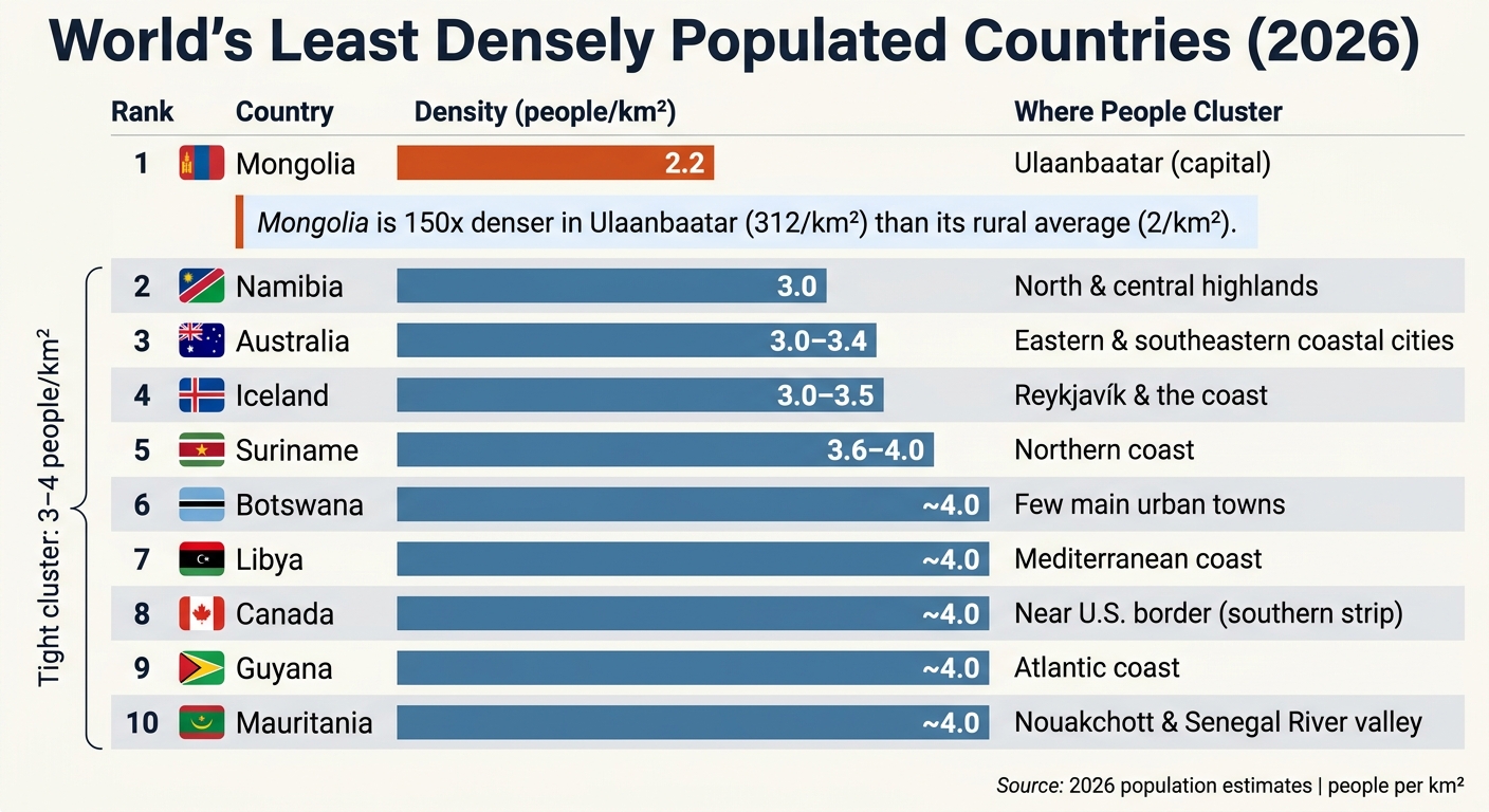
| Country | Density (people per km²) | Main population pattern |
|---|---|---|
| Mongolia | 2.2 | Heavy concentration in Ulaanbaatar |
| Namibia | 3.0 | Clustered in the north and central highlands |
| Australia | 3.0–3.4 | Mostly in coastal cities |
| Iceland | 3.0–3.5 | Mostly near Reykjavík and the coast |
| Suriname | 3.6–4.0 | Mostly along the northern coast |
| Botswana | About 4.0 | Spread across a few main towns |
| Libya | About 4.0 | Packed along the Mediterranean coast |
| Canada | About 4.0 | Concentrated near the U.S. border |
| Guyana | About 4.0 | Mostly along the Atlantic coast |
| Mauritania | About 4.0 | Centered on Nouakchott and the Senegal River valley |
So if you’re asking, “Which countries feel the most empty?” this list gives you the clearest answer. They are not empty by accident – their land, weather, and settlement patterns leave only small parts of each country fit for large populations.
sbb-itb-39d39a6
Why These Countries Are So Sparsely Populated
These rankings reflect more than land area. They show where people can actually live. Many of these countries have low population density because geography, climate, and land use leave only a small share of land fit for large settlements.
One of the biggest limits is land that can’t support farming. In Mongolia, less than 1% of the land is arable. Namibia has only 1% arable land. If farming can’t happen at scale, towns and cities usually stay small and far apart. Climate makes that even harder. Canada’s northern territories are largely uninhabitable because of arctic tundra conditions. The Sahara covers most of Libya’s interior. And in Suriname, dense tropical rainforest covers more than 90% of the country’s land area. Those aren’t minor hurdles. They’re hard physical limits that keep population density low, even in countries with a lot of land.
You can see the pattern in where people live. Populations bunch up near rivers, coastlines, and capital cities, while huge stretches of land stay mostly empty. About 90% of Canadians live within 240 kilometers of the U.S. border. Nearly half of Mongolia’s population lives in Ulaanbaatar. In desert countries, people gather near rivers and coasts because that’s where farming and trade can work. That’s a big reason these density figures are so low.
Those limits play out in different ways from one country to the next, starting with Mongolia.
1. Mongolia
Mongolia ranks first as the least densely populated sovereign country on Earth, with about 2.2 people per square kilometer – or 5.7 per square mile – as of 2026. The country has roughly 3.4 million people across 1.56 million square kilometers, which also makes it the world’s 18th-largest country by area.
The main reason comes down to the land itself. The Gobi Desert covers much of the south. The north and west are lined with rugged mountains. Between them sits a huge central steppe. Put simply, much of Mongolia is steppe, desert, or mountain terrain, so there isn’t much room for dense, settled farming.
The climate makes life even harder. Winter temperatures often fall below -22°F (-30°C), and severe dzud winters return again and again. In early 2024, one dzud killed more than 7 million animals – about 10% of the national herd. That kind of loss hits hard in a country where livestock still shapes daily life.
Most services are packed into Ulaanbaatar, while the rest of the country stays lightly settled. The capital reaches 312 people per square kilometer, compared with only 2 people per square kilometer across the rest of Mongolia. That makes Ulaanbaatar more than 150 times denser than the rural average. Outside the capital, about 30% of the population still lives nomadically, moving livestock across the steppe in traditional gers, or yurts.
Life beyond Ulaanbaatar can feel stark. Roads are often unpaved or poorly marked. Many rural homes don’t have formal street addresses. Healthcare and schools are still centered in the capital. For travelers or people thinking about relocating, rural Mongolia often means long travel times, thin access to care, and very few services. Namibia comes next, where arid land and water scarcity shape a different kind of low-density country.
2. Namibia
Namibia ranks second, with about 3 people per square kilometer spread across 824,000 square kilometers. Even with all that space, the country has fewer than 3 million people.
The main limit on settlement in Namibia isn’t land. It’s water. Most of the country gets less than 10 inches (250 mm) of rain per year, which is well below the 16 to 20 inches (400 to 500 mm) usually needed for rain-fed crops. The Namib Desert lines the Atlantic coast, while the Kalahari stretches across the east. Put simply, large parts of Namibia are too dry to support dense settlement.
So people gather where water is easier to reach. That means the central highlands and the northern parts of the country, especially near the Kunene and Okavango rivers. Those areas form a handful of livable corridors, and most of the population sits within them. Windhoek, the capital and main population hub in the central highlands, has about 431,000 residents.
Distance adds another problem. Even with good roads, it is expensive to keep services running across such a large country. Rural communities still deal with gaps in healthcare, schools, and steady internet access. In ranching areas, neighbors can live miles apart, and livestock operations need large stretches of fragile grazing land.
3. Australia
Australia follows a pattern similar to Mongolia and Namibia: it’s a huge country, but most people live near the coast. The country has about 3 to 3.4 people per square kilometer, which puts it among the least densely populated sovereign countries in the world.
Most Australians live in coastal cities like Sydney, Melbourne, and Brisbane, mainly along the eastern and southeastern parts of the country. Much of the interior is the Outback, where dry conditions and limited water make large areas hard to inhabit. Places like the Simpson Desert and the Kimberley region show just how much the landscape shapes where settlement can happen.
That geography affects more than population maps. It also makes day-to-day life harder in many parts of the country. Building and maintaining highways, power grids, and reliable internet across such long distances costs a lot. For residents and travelers alike, that can mean long drives, fewer services, and thinner access to healthcare and schools.
4. Suriname
Suriname is sparse too, with only about 3.6 to 4 people per square kilometer.
The main reason is the rainforest. More than 90% of the country is covered by dense tropical rainforest, which makes large-scale settlement in the interior hard. Much of that inland area is either protected forest or tough to reach. In many places, rivers such as the Suriname and Marowijne work as the main transport routes for remote communities. So in practice, most long-term settlement stays near the coast and along river corridors.
The population is packed most tightly along the northeastern coast. The capital, Paramaribo, has around 240,000 people, or close to 40% of Suriname’s national population of about 592,000. Farther inland, communities are more isolated and tend to sit along river systems.
That setup leads to clear infrastructure gaps. When small populations are scattered across rough terrain, it becomes hard to justify the cost of roads, schools, and healthcare facilities in the interior. Outside Paramaribo, access to hospitals, schools, and stable communications is limited. In many areas, day-to-day life depends more on local networks than on central services. That same split between coast and interior shows up in the next country too.
5. Botswana
Botswana has about 4 people per square kilometer, which puts it among the least densely populated countries in the world.
The main constraint here isn’t land. It’s water. Much of the country is arid, water is scarce, and that makes farming hard. As a result, permanent settlement stays thin, and jobs and investment tend to cluster in a limited number of areas.
Diamond mining makes up a large share of national GDP, while tourism built around the Okavango Delta has become a major part of the economy. Visitors are drawn to luxury safari lodges, and that model brings in money without dense development. In practice, both sectors concentrate economic activity in a small set of places instead of spreading it evenly across the country.
Distance adds another layer of difficulty. Roads, power, healthcare, and schools cost a lot to maintain across such long stretches. For people living far from economic centers, daily life often calls for more self-reliance, with homes sometimes separated by kilometers. The same pattern shows up in other low-density countries, where geography leaves settlement scattered and public services thin.
6. Iceland
Iceland is a different kind of low-density country. Ice, volcanoes, and rough terrain push most people toward the coast. The country has about 3 to 3.5 people per square kilometer, which puts it among the least densely populated countries in Europe.
The interior is shaped by glaciers, volcanoes, and geothermal fields, so there isn’t much land fit for year-round settlement.
Most people live in Reykjavík, and the rest of the country is spread out in small pockets.
That pattern makes the interior expensive to serve. Roads, utilities, and other public services cost a lot to build and maintain across such a large, geologically active landscape.
Low density also affects tourism. Activities like ice caving, glacier hiking, and visits to geothermal springs pull in travelers in part because so much of the land has remained untouched.
The next country on the list shows how desert, not ice, can lead to the same outcome.
7. Libya
Libya has about 4 people per square kilometer. But that number doesn’t tell the whole story. The country isn’t lightly settled in a balanced way. Instead, people are packed into a small part of the map, while most of the rest is almost empty.
Libya spans 1.76 million square kilometers, and about 99% of it is Sahara Desert. In many inland areas, meaningful rain may not come for years. On top of that, only about 1% of Libya’s land is classified as agricultural. So in practice, the north coast becomes the country’s main living space.
Most Libyans live in a thin band along the Mediterranean. About 80% of the population lives in urban areas, and large coastal cities hold a big share of the population. Tripoli has around 1.1 million residents, while Benghazi has roughly 629,800. Step away from those coastal centers, and settlement drops off fast.
Libya also has no active rail network. Since so many people live along the coast, transport and water systems are built around that same corridor. One of the clearest examples is the Great Man-Made River, which moves groundwater from southern aquifers to cities in the north. Libya also depends on desalination and the Nubian Sandstone Aquifer.
Canada comes next, where cold and distance shape low density in a very different way.
8. Canada
Canada has about 4 people per square kilometer, even though it’s the world’s second-largest country by land area. That gap comes down to climate, distance, and sheer size.
A huge share of the north is simply too cold for dense settlement, especially Yukon, the Northwest Territories, and Nunavut. The Northwest Territories alone spans more than 1,144,000 square kilometers and has fewer than 45,000 people.
That national average can be misleading. Canada isn’t evenly settled at all. 90% of Canadians live within 240 kilometers of the U.S. border, packed into a narrow southern band. And more than 25% of the total population lives in just three metro areas: Toronto, Montreal, and Vancouver.
Outside those zones, much of the land is forest, tundra, or mountains. Add in lakes and long travel distances, and basic infrastructure gets expensive fast. Roads, railways, and power lines cost a lot more to build and maintain when communities are far apart. In many remote northern areas, that means weaker access to healthcare, education, and internet service.
Forests cover 38% of Canada, and protected land also limits where development can happen.
9. Guyana
Guyana has a population density of about 4 people per square kilometer. Most of the country’s people live along the settled northern coast, while the interior remains thinly populated. That split is the main reason density stays low, even with urban centers on the coast.
The interior is made up mostly of rainforest and savanna, which makes large-scale settlement harder. On top of that, rivers make overland transport expensive, so people and services stay concentrated near the coast.
That distance from the coast limits access to services and slows development. Offshore oil is bringing in new investment, but most of that development still clusters along the coast. Eco-tourism adds income to the sparsely populated interior, but it doesn’t change the basic settlement pattern.
Mauritania follows a similar pattern: people gather where water and access are available, while much of the land stays empty.
10. Mauritania
Mauritania follows the same desert-led pattern seen in other low-density countries, but here it’s even more extreme. Settlement is packed into a thin coastal strip and the river valley in the south. The country has about 4 people per square kilometer, mostly because around 90% of Mauritania is covered by the Sahara Desert. That leaves very little land where people can live, farm, or build permanent communities.
The climate makes that pattern easy to understand. Summer temperatures often climb past 113°F (45°C), and large parts of the interior can go years without meaningful rain. In the far south, the Senegal River plays a central role in where people settle. It’s one of the few places in the country that can support daily life at scale.
As a result, population clusters in two main areas:
- the southern Senegal River valley
- the Atlantic coast, especially the capital, Nouakchott
Roughly one-third of Mauritania’s population of about 5.2 million lives in Nouakchott alone. By contrast, the northern desert is mostly empty apart from oases and mining outposts. That sharp split leaves the interior thinly settled and channels much of the country’s infrastructure into a narrow coastal corridor.
Building across the desert is expensive, and keeping roads in usable shape is no small task. The iron ore rail line from Zouîrât to Nouadhibou is one of the few links that crosses the desert, and locals sometimes use it as well. Healthcare and electricity are concentrated in Nouakchott and Nouadhibou, which leaves many remote communities with limited access. On top of that, Mauritania loses 80,000 to 100,000 hectares of arable land each year to desertification, pushing more people toward coastal cities.
Quick Comparison: Density Figures at a Glance
Here’s the full comparison in one place. The figures use the latest available 2026 data and are rounded. Square-mile figures are included for U.S. readers.
| Country | People per km² | People per sq mi | Where People Cluster |
|---|---|---|---|
| Mongolia | 2.2 | 5.7 | About half live in Ulaanbaatar; many others remain nomadic herders |
| Namibia | 3.0 | 7.8 | Population clustered in the north and central highlands |
| Australia | 3.0 | 7.8 | Population concentrated in coastal cities; the interior is sparsely inhabited |
| Iceland | 3.0–3.5 | 7.8–9.1 | Most people live in Reykjavík |
| Suriname | 3.6–4.0 | 9.3–10.4 | Population concentrated along the northern coast |
| Botswana | about 4.0 | 10.4 | Population centered in a few urban areas; the Kalahari remains largely empty |
| Libya | about 4.0 | 10.4 | Population concentrated along the Mediterranean coast |
| Canada | about 4.0 | 10.4 | Population concentrated in the south; the north is thinly populated |
| Guyana | about 4.0 | 10.4 | Population concentrated along the Atlantic coast |
| Mauritania | about 4.0 | 10.4 | Population concentrated around Nouakchott and the Senegal River valley |
Mongolia stands apart. The other nine countries sit in a pretty tight band of about 3 to 4 people per square kilometer. And even though they’re spread across different regions of the world, the population pattern looks strikingly similar: people gather in a capital, along a coast, or near a river corridor, while huge parts of the country remain lightly settled.
That split matters in day-to-day life. It affects how far people travel for work, school, and health care. It also shapes the cost of roads, utilities, and public services, since serving a small population across a large area is expensive.
What Low Density Means for Travel, Relocation, and Infrastructure
Those low density figures show up fast in day-to-day life. In many cases, low density means people cluster in one city, along a coast, or near a river corridor. If you’re traveling through these places or thinking about moving there, that pattern changes almost everything.
Infrastructure is usually the first thing you feel. When people are spread out, roads, power lines, and internet service tend to stay close to the main population hubs. Mongolia is a clear example: most infrastructure is concentrated in Ulaanbaatar. In Canada, much of the population lives near the U.S. border, while the north remains thinly settled. The same setup affects mobile service and emergency response too.
Outside the main towns, connectivity drops off fast. In Namibia, travel through remote desert areas often means bringing a 4×4 and extra water.
Healthcare follows the same pattern. In Mongolia, care is free, but options are limited outside Ulaanbaatar. Remote communities in Namibia, Botswana, and Guyana run into the same issue. That’s the trade-off in plain terms: more room and less noise, but fewer nearby services.
For some people, that sounds ideal. More space, more quiet, and a slower pace can be a huge plus. For others, the loss of convenience and the need to plan around long distances is a dealbreaker.
Conclusion
Taken together, these countries point to the same basic story: small populations spread across huge or hard-to-live-in landscapes. Mongolia is the least densely populated sovereign country on Earth, with about 2.2 people per square kilometer. The rest of the list falls into a tight range of about 3 to 4 people per square kilometer, shaped by desert, tundra, rainforest, or long stretches far from roads, services, and major towns.
That’s why population patterns in these places often look similar. People gather in capitals, along the coast, or near river corridors, while most of the land remains lightly settled.
If you’re researching the world’s emptiest countries, these ten make the idea easy to picture. They show what low population density looks like on the ground – and how it affects travel, infrastructure, and daily life.
FAQs
How is population density calculated?
Population density is worked out by dividing a country or region’s total population by its total land area. It’s usually shown as the number of people per square kilometer or per square mile.
This gives you a solid snapshot at a glance. But it can also blur the picture, especially in places with large stretches of land where people can’t live. To get a closer look, demographers may also use physiological density or agricultural density.
Why do huge countries stay lightly populated?
Huge countries often have a lot of land on the map but far less land that people can live on with ease. Geography and climate do a lot of the sorting. Big stretches may be desert, frozen plain, steep mountains, or other terrain that’s tough for farming, housing, and transport. Water access can also be uneven, so people tend to gather in the parts of the country that are easier to live in.
Distance adds another problem. It costs more to build and maintain roads, power lines, schools, hospitals, and other services across long stretches of rough land. That makes dense settlement harder in many regions.
Settlement patterns matter too. In some places, people have long lived in ways that spread them out across the land instead of pulling them into large urban centers. Mongolia is a good example, where nomadic herding has helped keep the population dispersed.
Does low density make living there harder?
Often, yes. In countries with low population density, people live farther apart, and that makes roads, electricity, telecommunications, and other basic services more expensive to build and maintain.
That gap can shape daily life in a big way. People in remote areas may have a harder time reaching healthcare, schools, and other core services. Life in these places can build self-reliance and tight-knit communities, which many people value. At the same time, day-to-day convenience and economic opportunity may be more limited than in dense urban areas.
